
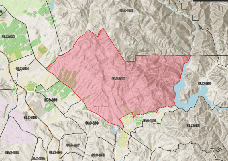
New Wildfire Evacuation Analysis Completed for Varian Ranch
The San Luis Obispo County Fire Safe Council have completed a planning-level Community Wildfire Evacuation Analysis for the Varian Ranch community and County Evacuation Zone SLC-258.
The analysis combines evacuation modeling, wildfire history, recorded ignition data, fire-spread simulations, electrical infrastructure, and designated evacuation routes to help residents and public safety agencies better understand the community’s wildfire evacuation conditions.
Evacuation Modeling Results
The LADRIS evacuation simulation evaluated 97 residential addresses and 185 passenger vehicles within the evacuation zone.
The simulation reported:
- 97 addresses evacuated
- 185 passenger vehicles
- 185 vehicles successfully departed and arrived
- Total modeled evacuation clearance time of 1 hour and 7 minutes
- Average modeled trip time of approximately 20 minutes
- Three evacuation waypoints serving the zone
The modeled result falls within the two-hour planning benchmark used for this analysis. However, the clearance time does not include every delay that may occur during an actual wildfire, including warning and preparation time, animal loading, roadway blockages, collisions, smoke, power failures, emergency-response activity, or traffic from neighboring evacuation zones.
Varian Ranch Evacuation Routes
The San Luis Obispo County evacuation-route map identifies Orcutt Road and Lopez Drive as primary evacuation routes in the Varian Ranch area.
Tiffany Ranch Road and connections toward Corbett Canyon Road are identified as secondary routes. Local streets—including Varian Circle, Wild Way, Watercress Way, and surrounding neighborhood roads—connect residents to the larger evacuation network.
These route classifications are intended for planning. A mapped primary or secondary route is not guaranteed to remain safe or open during a wildfire. Residents should always use the route directed by law enforcement and public safety officials.
Historic Wildfire Activity
The analysis includes the 1985 Las Pilitas Fire, one of the largest historic fires in the surrounding area.
CAL FIRE responded to the fire on June 30, 1985, and contained it on July 14, 1985. The fire burned approximately 84,271 acres east and northeast of Varian Ranch. The incident record identifies equipment-use activity as the cause.
Although the mapped fire perimeter did not extend through the Varian Ranch residential area, the Las Pilitas Fire demonstrates the potential for large, long-duration wildfires in the surrounding landscape.
Historic Ignition Data
Recorded ignition data from 1999 through 2022 shows numerous wildfire ignitions along developed roads and areas of human activity surrounding Varian Ranch and extending toward Lopez Lake.
The ignition pattern supports continued prevention efforts involving:
- Roadside vegetation management
- Utility corridors
- Equipment-use areas
- Agricultural activities
- Mowing, welding, and other spark-producing operations
- Public-use areas and access points
The data also shows that a wildfire threatening Varian Ranch may begin outside the immediate residential area.
Fire-Spread Simulations
Three wildfire scenarios were evaluated to understand how fires approaching from different directions could threaten the community.
Fire Approaching from the North
The north-origin simulation showed a fire advancing toward developed areas north of Orcutt Road and producing additional fire growth near the community’s western approach.
The displayed scenario showed 19 mph winds, 7 hours and 17 minutes of fire progression, and approximately 400 acres burned.
Roadside Fire Along Orcutt Road
The roadside simulation began immediately adjacent to Orcutt Road near the Varian Ranch access area.
After 1 hour and 35 minutes, the simulation showed approximately 35 acres burned. Although smaller in acreage, this scenario is especially important because smoke, fire, emergency apparatus, or a road closure could affect the community’s primary evacuation corridor early in the incident.
Fire Approaching from the South
The south-origin simulation showed a larger fire moving through the hills east and southeast of Varian Ranch and approaching the residential area and connecting roadways.
The displayed scenario showed 20 mph winds, 14 hours and 20 minutes of progression, and approximately 1,044 acres burned.
These simulations are planning scenarios—not forecasts. Actual fire behavior will depend on weather, fuels, topography, fuel moisture, suppression activity, and the location and time of the ignition.
PG&E Infrastructure and Power Outages
The analysis also reviews PG&E electrical infrastructure serving the developed portions of Varian Ranch and the Lopez Lake corridor.
Electrical lines generally follow or cross several roadways that may also be used for evacuation and emergency access. Damaged poles, fallen conductors, vegetation, or utility-response operations could affect these routes during a wildfire.
Residents should also prepare for a Public Safety Power Shutoff or wildfire-related outage that could affect:
- Electric gates
- Wells and water pumps
- Medical equipment
- Internet and cellular communications
- Lighting and security systems
Gates should have a manual-opening procedure, and residents who depend on electrically powered medical or water systems should maintain an appropriate backup-power plan.
Recommended Community Actions
The analysis recommends that the Varian Ranch community:
- Verify all primary, secondary, and alternate evacuation routes.
- Document gates, bridges, culverts, narrow roads, and turnaround limitations.
- Register residents for official San Luis Obispo County emergency alerts.
- Identify residents who may need transportation, mobility, medical, or notification assistance.
- Develop an animal and livestock evacuation plan.
- Maintain visible address signs, roadside vegetation, driveways, and emergency turnarounds.
- Prepare for power outages and establish manual gate-opening procedures.
- Coordinate with PG&E regarding vegetation management and electrical infrastructure.
- Conduct additional evacuation modeling with individual routes or waypoints unavailable.
- Use the north, south, and Orcutt Road fire scenarios to help public safety agencies establish evacuation decision points and route-closure contingencies.
Preparation Is the Key
The evacuation model produced a favorable planning-level clearance time, but successful evacuation will depend on early warning, resident readiness, usable roads, functioning gates, and leaving before fire or emergency operations compromise Orcutt Road or another critical route.
Residents should register for official emergency alerts, maintain evacuation go-kits, keep vehicles fueled or charged, plan for pets and livestock, and be prepared to leave promptly when directed by public safety officials.
The Varian Ranch Community Wildfire Evacuation Analysis is intended to support community preparedness and coordination. It does not guarantee that evacuation routes will remain available or that evacuation can be completed safely under every wildfire condition.