The San Luis Obispo County wildfire season is approaching, and communities now have a powerful new preparedness tool: the Wildfire Evacuation Planning Guide, officially approved and ready for distribution ahead of this year’s peak fire conditions. This guide represents the latest step in a countywide effort led by the San Luis Obispo County Fire Safe Council to deliver clear, consistent, and accessible evacuation information for residents across the Central Coast.
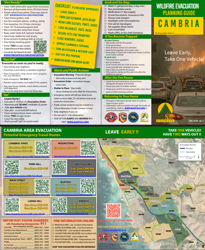
CAMBRIA WILFIRE EVACUATION PLANNING GUIDE
A Countywide Collaboration Focused on Public Safety
The Wildfire Evacuation Planning Guide was developed through coordination between the San Luis Obispo County Fire Safe Council, CAL FIRE San Luis Obispo, the County Office of Emergency Services, the Cambria Fire Department, and the County Fire Chiefs Association. Each partner contributed neighborhood-level insights, state guidance, traffic analysis, and wildfire behavior expertise to ensure the guide reflects real-world conditions and supports safe, orderly evacuations.

This guide builds on previous successful community tools, such as the Cambria Evacuation Guide, and now expands into a standardized countywide format.
Paired With the FireSafeSLO Evacuation Information Viewer
Residents can use the printed guide alongside the online Evacuation Information Viewer at FireSafeSLO.org/evacuation. The viewer allows users to type in their address, identify their evacuation zone, and review preferred evacuation routes. It also displays live evacuation status during active incidents and links to ReadySLO alerts and official public safety updates.

FSC COUNTYWIDE EVACUATION VIEWER APP
Together, the printed guide and the interactive map give residents both a physical and digital way to prepare before an emergency and stay informed during one.
Designed for Accessibility and Readability
Every map and graphic in the Wildfire Evacuation Planning Guide was created to meet ADA accessibility standards. Color contrast, labeling, symbol shape, and text size were tested for clarity, and QR codes were optimized so they can be scanned even from grayscale prints. This ensures every resident, including those with vision limitations, can interpret evacuation routes and zone boundaries safely.
Built Using Real Evacuation Simulations
A key advancement in this new guide is its use of AI-powered evacuation simulations. These simulations draw from local GIS data, traffic constraints, community access points, and historical fire behavior to identify the safest and most efficient evacuation routes for each neighborhood.
This ensures the guidance provided is not theoretical—it’s based on tested, data-driven modeling tailored to the terrain and road networks of our communities.
Comprehensive, Action-Oriented Preparedness Steps
The Wildfire Evacuation Planning Guide is designed to be a practical tool that residents can keep on hand year-round. It includes information and links to:
Before Fire Season
• Home hardening recommendations
• Defensible space reminders
• Emergency alert registration and family communication planning
During High Fire Conditions
• Steps to get “Set” under the Ready, Set, Go framework
• Securing outdoor items, preparing pets, and gathering medications
• Reviewing evacuation zone maps and primary routes
When an Evacuation Order Is Issued
• How to leave immediately and safely
• What to pack in minutes
• How to drive through smoke, embers, or reduced visibility
• When to use alternate or secondary routes
If You Become Temporarily Trapped
• Identifying temporary refuge areas
• Sheltering safely in vehicles or cleared spaces
• What information to give 911 for rapid location
After the Fire
• Understanding re-entry procedures
• Identifying post-fire hazards like ash pits, unstable trees, and damaged utilities
• Steps for documenting impacts for insurance and recovery
Print-Ready, Easy to Use, and Community Friendly
The guide is formatted for legal-size paper, double-sided printing, and real-world distribution at community meetings, fire stations, city halls, and neighborhood outreach events. It includes visible space for residents to write down their address, zone number, and any special needs or notes for their household plan.
Strengthening Countywide Wildfire Readiness
Together, the Wildfire Evacuation Planning Guide and the FireSafeSLO Evacuation Viewer deliver a unified, modern system for evacuation preparedness in San Luis Obispo County. They are:
• Simple and intuitive
• Accurate and data-driven
• Accessible for all residents
• Grounded in real evacuation modeling
• Built for practical use during emergencies
As the wildfire landscape continues to change, these tools help ensure every household has the information needed to act quickly, confidently, and safely when the next wildfire threatens.